Alexandria has many important Historic sites within its large historic district. Unfortunately, only a few sites pertaining to its once extensive railroad heritage have survived.
Union Street, which at one time was the northern terminus of the line, no longer has tracks run along its length, and only a few of the warehouses the railroad served have survived. One remains standing at Union and King Street.
The historic O & A Wilkes Street Tunnel still exists, today it is used as a pedestrian/bicycle path.
A townhouse development now covers the site of the former O & A rail yard near Duke and Henry Street and none of the railroad buildings stand. The pool house within the development was built to resemble a scaled down version of the roundhouse.
Adjacent to the National Cemetery one can view the Hoof’s Run Bridge built by the railroad in 1851 and enlarged in the years after the war when the bridge was multi-tracked.
West of Hoof’s Run is the area of Cameron Mills that, during the 19 th century, had many milling operations that were serviced by the railroad. Most traces from the nineteenth century are gone, however one mill building, Brown's Mill, still stands along Wheeler Drive north of the Railroad tracks.
At the Far west end of the current city limits is the Cameron Run Regional Park. Today it is mainly a recreational area, but a walking trail will take you to the place where the present railroad bridge crosses a widened Cameron Run.
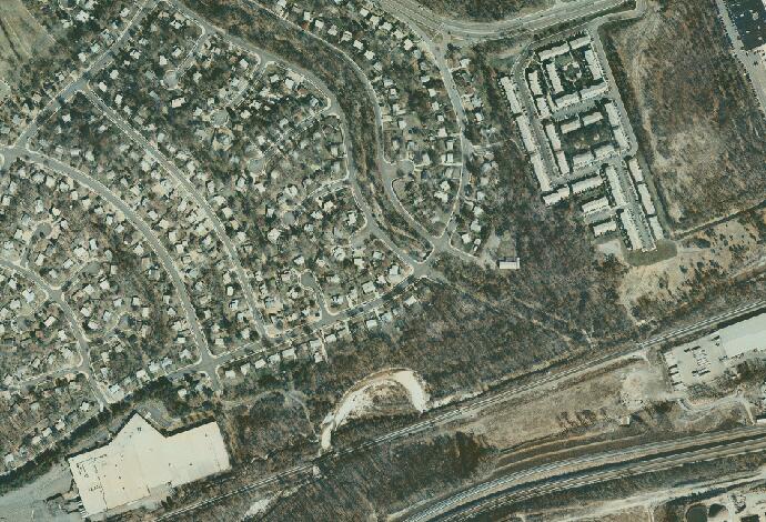
“Mount Hebron”, the farm of Horace Edsall, is now covered by a housing development. Little of historic interest remains though the height of Edsall’s Hill, a prominent Federal Picket post, can still be appreciated. The USMRR siding and depot site south of Edsall’s Hill is on private property within a Business Park and not readily accessible.
Development and the Capitol Beltway have long ago destroyed the historic ambiance of the Springfield Station area. Fairfax County has placed an historic marker at the entrance to the VRE commuter parking lot giving the history of the vanished station house that stood near the western end of the current platform. The bridge east of the platform sits on the historic stonework of the original 1851 bridge.
Nothing remains of Henry Daingerfield’s farm “Springfield”, the farm is now covered by Lynbrook School, the Capitol Beltway, and various adjacent housing developments.
Lake Accotink Regional Park is a designated Rails-to-trails park. Large portions of the original O & A Road-bed are preserved in the park and you can walk miles of the historic old main line as far as the Rolling Road crossing. Near the Park office is an original stone culvert in excellent condition. There are other historic culverts along the trail. While the park includes many historic wartime features including the sites of partisan attacks on the railroad, these are unmarked.
A Civil War Trails Marker is at the site of the 72 foot high 1948 bridge over Accotink Creek. The historic bridge, which was partially burned by J.E.B. Stuart’s Cavalry in December 1862, stood just north of the dam and is now under the lake waters.
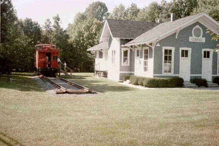
The circa-1870 Railroad Depot still stands, but has been moved slightly from its original site and much altered when it was converted into a church and later a real estate office. The present railroad tracks were moved north of the original bed in 1903. Portions of the original bed may be seen just to the east of the former depot in a community park. A stone culvert survives near Burke Station resident John Marshall’s Gravesite.
The Silas Burke house remains standing on the hill south of the station and is marked by a Virginia historic marker, although the house itself remains private. The Burke family cemetery is nearby but also on private property.
West of Burke Station one can access the area along Pohick Creek through Coffer Park. Remains of the track bed, a small culvert, and a post-war concrete water tank platform may still be seen. The Railroad Bridge over Pohick Creek today stands on the foundation stones of the original span.
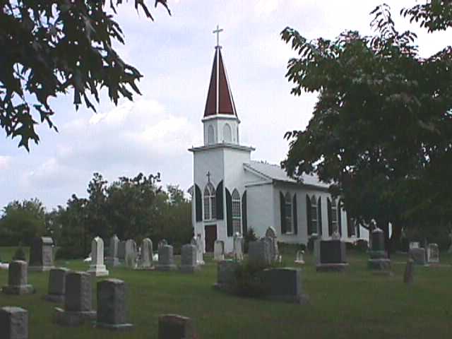
The antebellum station that stood on the south side of the tracks was burned during the war and there appears to be nothing left of the 19 th century USMRR buildings seen in wartime photographs. The pre-war built St. Mary’s Church still stands in a very pleasant setting with Civil War Trails Marker.
The circa-1903 Station has been moved away from the tracks and converted to a Railroad Museum containing displays and old photographs of the village. Another Civil War Trails Marker is located here. Historic earthwork remains can still be found in the area, however they are on private property.
The Station and nearby County Poor House are long gone. However, with the moving of the tracks to the north of the historic route in 1903, much of the historic Roadbed and the Pope’s Head Creek bridge sites have survived, but these are on private property and generally inaccessible to the public.
Despite the restriction of access, portions of the old Rail bed and station site off Colchester Road, now used as a private driveway, as well as the nearby site of the old Poor House can be seen from the public road.
A caboose and a Virginia historic marker point out the1903-era post-war station site. A walking tour brochure of the historic village is available which includes The William Beckwith House, the only pre-war house in the town. Clifton Town Park preserves remnants of the O&A Rail bed and a bridge abutment at Pope’s Head Creek. Northeast of town, Chapel Road Park allows viewing of some of the rail bed and two additional bridge sites (the railroad sites are on private property).These parks are public accessible, but parking is very limited.
Preserved within Hemlock Overlook Regional Park and along the Bull Run/Occoquan Trail are the remains of a Union blockhouse, entrenchments, building remains, USMRR rail siding site, sites of fords, and the abutments of the Bull Run railroad bridge. Unfortunately, while the sites are publicly accessible, none of them are marked or interpreted. Other sites of earthworks and campgrounds on the Prince William side of Bull Run are also extant, but these are more difficult to reach and are also unmarked.
The town visitor center is located in the 1914 railroad station that sits on the site of the siding where Jackson’s Confederates destroyed Pope’s stores in 1862.
Within the building is a small museum with artifacts documenting the rail history of the area. The city museum across the street also contains exhibits on the railroad.
A Walking/Driving Tour brochure along with Interpretive Markers throughout the town point out sites of Civil War and railroad interest. The Manassas National Battlefield Park, north of town, has additional information on the two Civil War battles fought for this area.
Other sites include an original sandstone culvert near the commuter lot off Prince William Street, Mayfield Fort constructed by Confederate forces to protect the vital rail junction may be toured and is well interpreted, and nearby Signal Hill Park also preserves earthworks. The Conner House, used as a hospital and part of the 1862 Bull Run Bridge engagement area, is currently being restored and has Civil War trails markers.
Another fort south of town was constructed by Union forces for the protection of the rail bridge over Cannon Branch, but is not yet developed for public visitation.
The rail junction with the former Manassas Gap Railroad is today an active maintenance yard that is off limits to the public, although the junction can be viewed from public streets.
Incidentally, A day-trip drive along the route of the old Manassas Gap Railroad into the Shenandoah Valley is very rewarding, especially once you are beyond the town of Haymarket. Many of the old depots remain standing and there is much pretty scenery and many historic sites and towns along the way.
Now known as Bristow, the area retains integrity as a small railroad village. A large house stands on the foundation of the Thomas Davis house, destroyed during the war, and there is an old house of unknown vintage standing on what has been referred to as the Dodd house site on wartime maps. The station no longer stands.
A Battlefield Heritage Park, commemorating the October 1863 battle along the tracks, is open to the public with plans for interpretive markers to be installed in the spring of 2008. The bridge over Broad Run may be viewed from the north side of the creek but is a 20 th century structure on the same site as the wartime bridge. The bridge over Kettle Run is inaccessible to the public.
A charming little village that became an official stop in 1865. Many of the buildings in the village today date to the turn of the century.
During the war, the area was part of the Orville Nokes “White Hall” farm. “White Hall” no longer stands, but the house stood on the knoll south of the railroad behind the present Antique shop.
Two Virginia Historic Markers stand at either end of the village describing John Mosby and J.E.B. Stuart’s activities here.
The wartime station house once stood on the southeast side of the tracks. The Edmond’s Place, supposedly built in 1862, still stands and is currently unoccupied. A Civil War Trails Marker that describes J.E.B. Stuart’s Raid at Catlett’s Station in 1862 sits on the south side of the tracks.
The Cedar Run Bridge can still be seen south of the village, but only scattered blocks from the wartime bridge and a 20 th century structure remain. Remnants of earlier vehicle bridges also remain. The Bailey Shumate farm, where some of Pope’s wagons were parked south of Cedar Run when Stuart raided, has a postwar structure near the site of the wartime home and is private property.
The junction still remains in its original location, however the station that sat within the junction is long gone. An old road trace can still be seen, which ran in front of the old Weaver house that no longer stands. The Owl Run Bridge at the southern end of the junction incorporates blocks from the original bridge, but can only be accessed through private railroad property.
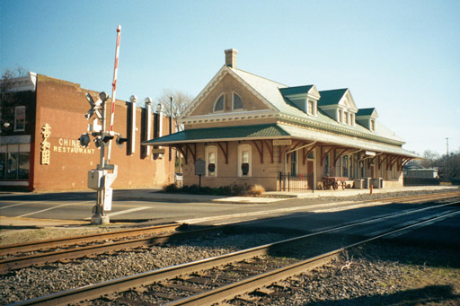
The Warrenton Branch no longer reaches Warrenton but the Southern railway depot still stands (it's currently a restaurant) and the abandoned right of way within the city has been turned into a bike/hike trail.
Nothing remains of the wartime depot buildings that were burned in 1863. The Southern-era railway station has been moved from the tracks and re-located near the library and currently awaits restoration. Little else of historic interest remains to be seen. From Bealeton, Remington Road follows alongside the Railroad for several miles, climbing 340-foot Lucky Hill.
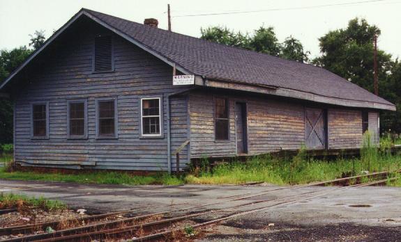
A Civil War Trails Marker describes the Battle here in 1863. The growth of Remington has obliterated much of the historic pre-war setting. However abutments of the bridge over Tinpot Run are extant, The Southern-era Freight Depot still stands near the site of the wartime depot, the sites of Confederate fortifications and battery positions can be viewed near the river, and the railroad bridge across the Rappahannock River can be seen downstream of the auto crossing.
A wartime structure, now known as “the Graffiti House”, is the visitor center for the Brandy Station Battlefield. There are many antebellum structures throughout the area and a driving tour is available for the nearby battlefield.
One mile to the north is the site of "Ingall’s Station" a USMRR siding for a Quartermaster repair depot in 1864. Nothing of wartime vintage remains, but the fields south of the tracks was where the Federal Army kept its cattle supply. Near this siding grew the present village of Elkwood, a late 19 th century stop on the Virginia Midland R.R..
On the north side of the tracks south of Brandy, at present Inlet, is the site of Lee’s review of General Stuart’s Cavalry prior to the Battle of Brandy Station. A Virginia Historic Marker denotes the event.
The town visitor center is housed in the restored 1904 station. A Civil War Trails Marker adjacent to the station relates the cavalry fight here. Walking and Driving tours of the town and the county’s battlefields are available and the museum, located on main street, has exhibits and information on the history of the county and railroad.
Several antebellum structures remain near this station site, all private. The station itself is gone as is the William Mitchell farmhouse that stood south of the station.
The battlefield of Cedar Mountain, fought in August of 1862, is just to the west of the station. A driving tour brochure of the battlefield is available at the Culpeper Visitor Center.
The Railroad was moved in 1903 preserving the historic setting of this village. The passenger depot, circa 1870, and the freight depot, both stand. They are both private property but are easily viewable from the public road. A caboose, in very bad need of restoration, sits near the passenger station.
Several other antebellum structures remain in the area as well as the post-war mill along the Rapidan River. The impressive 40-foot high original O & A Rapidan River bridge abutments and a pier in the river remain adjacent to the current bridge and can be viewed from the Orange County side of the river just past the mill.
The early 20 th century Railroad Station is now the town Visitor Center with interpretive exhibits and information. The wartime courthouse is just up the road and other historic structures are included in a walking tour brochure. The Sarah Bull house, in front of which a deadly troop train collision occurred in 1861, still stands but is private.
A large hotel/tavern building of unknown vintage remains standing. From the hill east of the tracks one can see, vegetation permitting, an original O & A stone bridge over Madison Run. A skirmish took place near the bridge in 1862.
The Cowherd Farm, William Mahone’s winter ’63-64 headquarters is located about 1 mile south of the village.
The junction of the two railroads remains in its historic roadbed. During the war, each railroad had separate depots. The O & A’s depot, which stood at the end of East Street, is gone. However, the antebellum Virginia Central freight depot still stands, which awaits restoration.
Near the depot, The Exchange Hotel, which sits directly on the former Virginia Central RR, is now a Civil War museum.
The town of Gordonsville has many pre-war homes and churches, check with the folks at the Exchange Museum for more information.
From Gordonsville to Charlottesville, O & A trains ran on the Virginia Central tracks. Some of the stations along this stretch of line include Cobham, Keswick, and Shadwell. None of the wartime depots stand, but there are remnants of steam-era structures located at the sites. The separate wartime Charlottesville depots were destroyed during the war, but the early 20 th century Union Station, that served both lines, remains standing.
At Charlottesville the Virginia Central and O & A diverged once again. The
O & A continuing to Lynchburg on its southern extension and the Virginia Central heading west into the Valley.